Accelerating Critical Insights: Making Near-Real-Time Missions a Reality
Joining the Maxar Intelligence journey at such a pivotal milestone has been exhilarating. Since I came on board as VP MEA earlier this year, we have successfully launched four next-generation, high-performance satellites for our WorldView Legion fleet. The new satellites deliver the highest image quality and geometric accuracy possible today. Providing high resolution imagery with peak revisit rates, more point target collection opportunities and greater temporal diversity, their performance and capabilities are groundbreaking.
When all six WorldView Legion satellites are operational later this year, it will radically accelerate sensor-to-insight intelligence. We can now with dawn-to-dusk coverage more rapidly detect, identify and monitor threats. We can track and georegister items of interest, including from drone video. We can use 3D modelling for mission simulations and rehearsal. And so much more. Ultimately, these insights will facilitate rapid, accurate and timely decision-making, saving lives. This will completely transform missions.
The capabilities provided by Maxar will be a game changer, both for the defense sector, but also other sectors such as oil and gas, urban planning, forestation, deforestation and much more. We will have triple the capacity available for our customers, which means that you can have anywhere between six and fifteen revisits of your area of interest every single day of the year. The Mean-Time to Access improves to less than four hours. This will have a tremendous impact for urgent on-the-ground operations.
Add to that the exquisite 30cm-class imagery covering more than 6 million square kms globally. Collected daily, multiple revisits provide mission-critical detail, accuracy and reliability. Our new Mid Inclination Orbit (MIO) capability now gives dawn-to-dusk imagery. In today’s complex geopolitical landscape, knowledge is power. The data we provide you is timely and accurate, giving you the power of geospatial intelligence to predict and deter any adversary operations. Multiple passes and look angles increase information and insight for previously hard to see areas. We have also integrated other multi-sensor data – such as Umbra’s Synthetic Aperture Radar. I believe this significantly raises the bar with the provision of not only day and night data, but also in all weather conditions.
The third aspect that impressed me was our ability to provide you, our customer, with end-to-end solutions to many of your geospatial data requirements. How? By combining our space segment capabilities with powerful analytics, algorithms, Artificial Intelligence (AI) and Machine Learning (ML). This hugely accelerates the speed, scale and quality of data processing and analysis: supplying near-real-time threat detection and identification. Not only that, but also 3D models can be overlayed with recent operational data for training, mission rehearsal and planning. We can also now georegister drone imagery such as full motion video, resulting in a highly useful accuracy of less than three meters.
Accelerating Insights
I would highlight that the significance around this massive increase in very high resolution capacity and increased revisit times is that Defense and security forces can have now access, more quickly, not only to very high resolution imagery but also to actionable insights. This delivers ground truth and data in near-real-time, which is critical to timely decision making, helping to keep nations safe, to improve maritime security, to protect and manage natural resources, to speed up disaster response, plan and execute missions and more. I find it inspirational how these capabilities are driving a significant evolution in intelligence for both the military and civil sectors.
We are currently running a several interesting pilots and proof of concepts. I invite you to talk to us about that during the Global Aerospace Summit for an under-the-hood preview. I will also elaborate here on these innovative examples.
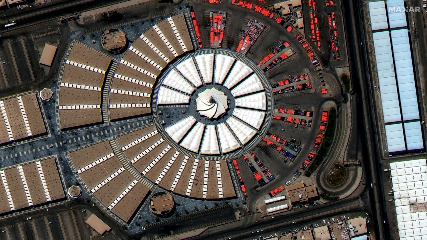
Take a look at this first WorldView Legion image – the intricate details that 30-cm class imagery can reveal.

This incredible 30 cm-class satellite image of the New Haraj Market in Riyadh, Saudi Arabia, collected by WorldView Legion, features an intricate architectural design that is best seen from above. It shows the indoor and outdoor stalls and the vibrant colors of the tents. Even the different floor tile patterns are clearly distinguishable.
For me, this image emphasizes the value of high-resolution satellite imagery for site monitoring, precision mapping, object detection, geospatial analytics, and more. How would your mission benefit if you had access to this quality of imagery up to 15 times daily over your areas of interest?
A different point of view
The WorldView Legion fleet includes the first Maxar satellites in mid-inclination orbit, or MIO, meaning they orbit around Earth's center rather than over its poles as in sun-synchronous orbit (SSO). Satellites in SSO typically collect imagery from mid-morning to early afternoon, but expanding to MIO enables dawn-to-dusk collection worldwide and insight into previously hard to see areas.
The potential implications are exciting. Early this year, the UAE and Oman experienced unprecedented amounts of rain in 1 day. At least 18 people died during flash flooding in Oman, and travel was disrupted throughout the UAE, which is known to be home to the second largest airport in the world, a business and tourist hub. In such emergency situations, having access to frequently refreshed imagery from multiple points of view provides accurate data that is essential in planning and managing the crisis quickly, and efficiently minimizing any wasted time and efforts, to ensure business continuity and crisis recovery.
A Game-Changer for Defence
I’m particularly enthused by the capabilities for defense operations. Topline, you can identify and monitor threats, conduct secure and successful operations, deploying resources more efficiently and effectively than ever before. The potential mission impact of being able to monitor an evolving situation in near-real-time is phenomenal. With multiple daily revisits from different angles, you can assess what is actually happening, how the situation is evolving on the ground and refine your mission accordingly.
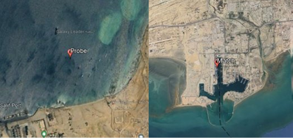
When combined with powerful AI and ML capabilities, the detail of 30 cm-class imagery enhances numerous defense applications. You can now track targets and areas of high interest, for example to maintain custody of vessels. You could “fingerprint” a suspicious ship, such as a sanctions violation, and determine a plan of action.

Ships in the Gulf of Oman. Possible match on ‘dark’ vessel imaged at two completely different locations. Vessel fingerprinting provides the ability to analyze historical activity and visited location of vessels that don’t transmit on AIS. You can build a network of locations associated with a single vessel of interest.
Detection: AI-powered detections now include the ability to identify the locations and types of military vehicles, aircraft, and armaments. Frequent monitoring of airports, seaports, and borders followed by the application of AI can also power rapid change detection, mapping patterns of change, and alerting operators to developing situations. Monitoring over large areas can also be employed to direct analysts’ attention to specific sites of activity or interest. We can automate time-consuming manual monitoring (and other tasks), freeing up human operators for more complex analysis and decision-making.
Positioning: The significant increase in high-resolution capacity will further improve the currency and quality of Maxar’s 3D data. We can now georegister full motion video and aerial imagery – from drones, planes and satellites - with Maxar's 3D data. This enables operators to identify their location within three meters of accuracy. This is a powerful tool for special forces interdiction, coordinating guided munitions, or deploying first responders following a disaster. This is also applicable to those operating in GPS degraded or denied environments.
An intelligent future
The launch of WorldView Legion marks more than just a technological leap forward for Maxar and our customers—it is a testament to the power of innovation and the relentless pursuit of clarity in a complex world. The breathtaking detail and high revisit rates are game-changers for anyone who relies on accurate, timely information to make life-saving decisions. Maxar has been leading innovation in space for decades, providing the world with excellence in imagery and geospatial intelligence data.
WorldView Legion embodies our commitment to helping our customers see the world in ways that were once unimaginable, to navigate challenges with precision, and to act decisively when it matters most. Our technology saves and improves lives.
Contact amal.ezzeddine@maxar.com to learn more.

